British School (16th Century) [WCM 3233]
THE ANDWELL MAP, 1530S
Pen and ink and watercolour; extensively inscribed (H. 24, W. 63 cm). WCM 3233.
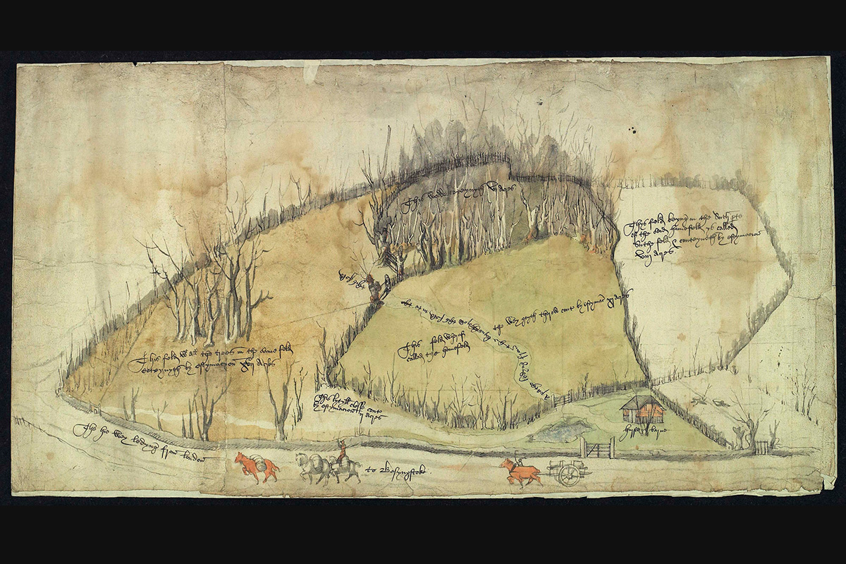
This picture of fields at Andwell, near Basingstoke, is one of the earliest known watercolour views of an English landscape. Documents in Winchester College’s archives indicate that the map was made to settle a legal dispute over the land’s ownership, which lasted for several decades during the sixteenth century.
Winchester College has owned land at Andwell since its foundation in the fourteenth century. In 1520, John Jakes, one of the College’s tenants in a part of Andwell known as Hurstland, became embroiled in a quarrel with a neighbouring farmer, John Hoke, over wood taken from the boundary between their properties. Despite an initial inquiry in which Hoke was seen to be at fault, the dispute continued for decades, falling into the next generation of the Jakes and Hoke families. Another inquiry was called in December 1536 but was ultimately unsuccessful. The feud finally came to a conclusion in March 1552, when the case was put to arbitrators to settle. Jakes’ right to collect timber from the College’s land was confirmed, and the neighbouring grove was equally divided between the two men. An archival document dated to 1536 records that William Waterman, a surveyor, ‘seyth he hath viewed and esteemed hurstlond’, perhaps indicating that the watercolour was created for the inquiry of the same year. The colour discrepancy between the fields suggests that the map may have been colour-coded to show which part belonged to whom.
In the early sixteenth century, maps created for legal use were typically drawn from a bird’s-eye perspective. Although the Andwell Map was made for a practical purpose, it is not purely topographical. The figures and trees are disproportionally large relative to the fields represented, and their details add life and an atmospheric quality to the picture. The path running along the lower part of the view is labelled as the road between London and Basingstoke (now the A30), and the carts and horses, whose front hooves are caught in mid-air, emphasise its busyness. The delicate shading of the tree trunks gives the illusion of light from a rising or setting sun, creating a sense that this not a schematic representation of the land, but a moment captured in time.
Literature: John Harvey, ‘Early Tudor Draughtsmen’, in L.G.G. Ramsey (ed.) The Connoisseur Coronation Book (London, 1953), pp. 97–102; Anthony Gerbino and Stephen Johnston, Compass & Rule: Architecture as Mathematical Practice in England, 1500-1750 (London, 2009), p. 33, 35; Michael Hicks (ed.), English inland trade, 1430-1540: Southampton and its region (Oxford, 2015), pp. 44–45; Suzanne Foster, ‘Andwell Map, 1530s’ in Richard Foster (ed.), 50 Treasures from Winchester College, pp. 74–75.
Provenance: Commissioned by Winchester College